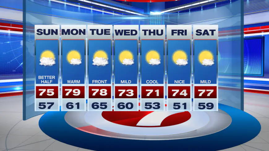
Up and Down Temperatures this Week
The roller coaster ride of temperatures will continue this week across South Florida courtesy of a couple of fronts. A cold front crossed through midday...

The roller coaster ride of temperatures will continue this week across South Florida courtesy of a couple of fronts.
A cold front crossed through midday Saturday, which has been responsible for the 50s much of the region is waking up to this Sunday morning. Then a second front will arrive late Tuesday, leading to another round of cold.
At least for our Sunday, it will be a beautiful day with sunshine and times of cloudiness. Brighter skies are favored across northern areas while clouds could be a bit more stubborn — at least at times — across southern locations like the Florida Keys.

Regardless, it will be a pleasant day with highs in the low to mid 70s paired with very light winds.
Temperatures tonight won’t be as cool with light and variable winds in play. Low temperatures for Monday morning will be near 60F across much of Miami-Dade and Broward.

An area of low pressure developing over the Gulf of Mexico will influence our weather Monday into Tuesday, ushering in warmer temperatures and a slight increase in humidity levels.

Attached to that low will be our next cold front, which then arrives late Tuesday. This next front will help draw in cooler temperatures for the second half of the week. There are additional variables at play with our long range weather pattern, so the magnitude and duration of this next cold wave is still somewhat uncertain, however.
A second low may form over the Gulf of Mexico during the second half of this week, too, which could bring in a rain chance later in the week depending on its track.

What's Your Reaction?


