System fueling California wildfires to bring wintry weather to wide swath of US
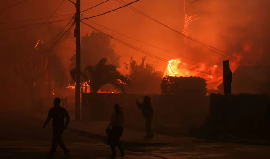
The low-pressure system that’s helping contribute to a rash of wildfires in southern California will eventually bring wintry weather to a wide swath of the U.S. including the Midwest. The fires, which have killed five people and have destroyed more than 1,000 buildings, are being fanned by a weather phenomenon known as Santa Ana winds, which howl through canyons and down mountain slopes and can cause wind gusts of up to 100 miles per hour at times. NOW: Get the latest coverage of this week’s wildfires via NBC Los Angeles According to NBC 5 Storm Team Meteorologist Brant Miller, the genesis of the dangerous weather pattern occurred this week thanks to a dome of high-pressure centered along the California coast and a low-pressure system over parts of Mexico. Those two systems are stuck in what is known as a “Rex block,” according to the Weather Channel. The block essentially traps the high-pressure dome in place, allowing for warm, dry weather to remain over southern California for a long stretch of time. The two systems also begin generating winds in the deserts of California, which then whip their way through canyons and down mountain sides into the valleys around Los Angeles, further drying things out and providing plenty of tinder that ultimately can fuel raging wildfires. What’s more, the wind could potentially cause toxic smoke, loaded with pollutants from burning building materials, to be trapped over Los Angeles, causing significant air quality issues in addition to the threat of wildfire damage. Eventually the “Rex block” will end, and the low-pressure system will start moving its way toward the east. As it gets over New Mexico and Texas, it will flare up into a significant storm system, potentially bringing snow and ice to a wide swath of Texas, including the Dallas area. That system will continue churning eastward, bringing snow and ice to parts of Kentucky, Tennessee, and even northern parts of Louisiana, Mississippi, Alabama and Georgia, according to forecast models. Ultimately, moisture from the system will push its way to the north, bringing some snow to parts of Illinois and Indiana. As for the Chicago area, some snow could occur, but accumulations will likely remain light, with only 1-to-2 inches of snow expected, with higher accumulations well to the south of Interstate 80, according to forecast models.

The low-pressure system that’s helping contribute to a rash of wildfires in southern California will eventually bring wintry weather to a wide swath of the U.S. including the Midwest.
The fires, which have killed five people and have destroyed more than 1,000 buildings, are being fanned by a weather phenomenon known as Santa Ana winds, which howl through canyons and down mountain slopes and can cause wind gusts of up to 100 miles per hour at times.
NOW: Get the latest coverage of this week’s wildfires via NBC Los Angeles
According to NBC 5 Storm Team Meteorologist Brant Miller, the genesis of the dangerous weather pattern occurred this week thanks to a dome of high-pressure centered along the California coast and a low-pressure system over parts of Mexico.
Those two systems are stuck in what is known as a “Rex block,” according to the Weather Channel. The block essentially traps the high-pressure dome in place, allowing for warm, dry weather to remain over southern California for a long stretch of time.
The two systems also begin generating winds in the deserts of California, which then whip their way through canyons and down mountain sides into the valleys around Los Angeles, further drying things out and providing plenty of tinder that ultimately can fuel raging wildfires.
What’s more, the wind could potentially cause toxic smoke, loaded with pollutants from burning building materials, to be trapped over Los Angeles, causing significant air quality issues in addition to the threat of wildfire damage.
Eventually the “Rex block” will end, and the low-pressure system will start moving its way toward the east. As it gets over New Mexico and Texas, it will flare up into a significant storm system, potentially bringing snow and ice to a wide swath of Texas, including the Dallas area.
That system will continue churning eastward, bringing snow and ice to parts of Kentucky, Tennessee, and even northern parts of Louisiana, Mississippi, Alabama and Georgia, according to forecast models.
Ultimately, moisture from the system will push its way to the north, bringing some snow to parts of Illinois and Indiana.
As for the Chicago area, some snow could occur, but accumulations will likely remain light, with only 1-to-2 inches of snow expected, with higher accumulations well to the south of Interstate 80, according to forecast models.
What's Your Reaction?


